If your dispatchers spend part of every day calling drivers to ask where they are, you already know the problem geofencing solves.
So, what is a geofence? It’s a digital perimeter around a location that tells you when a vehicle arrives, leaves or lingers, without anyone picking up the phone.
What Is a Geofence?
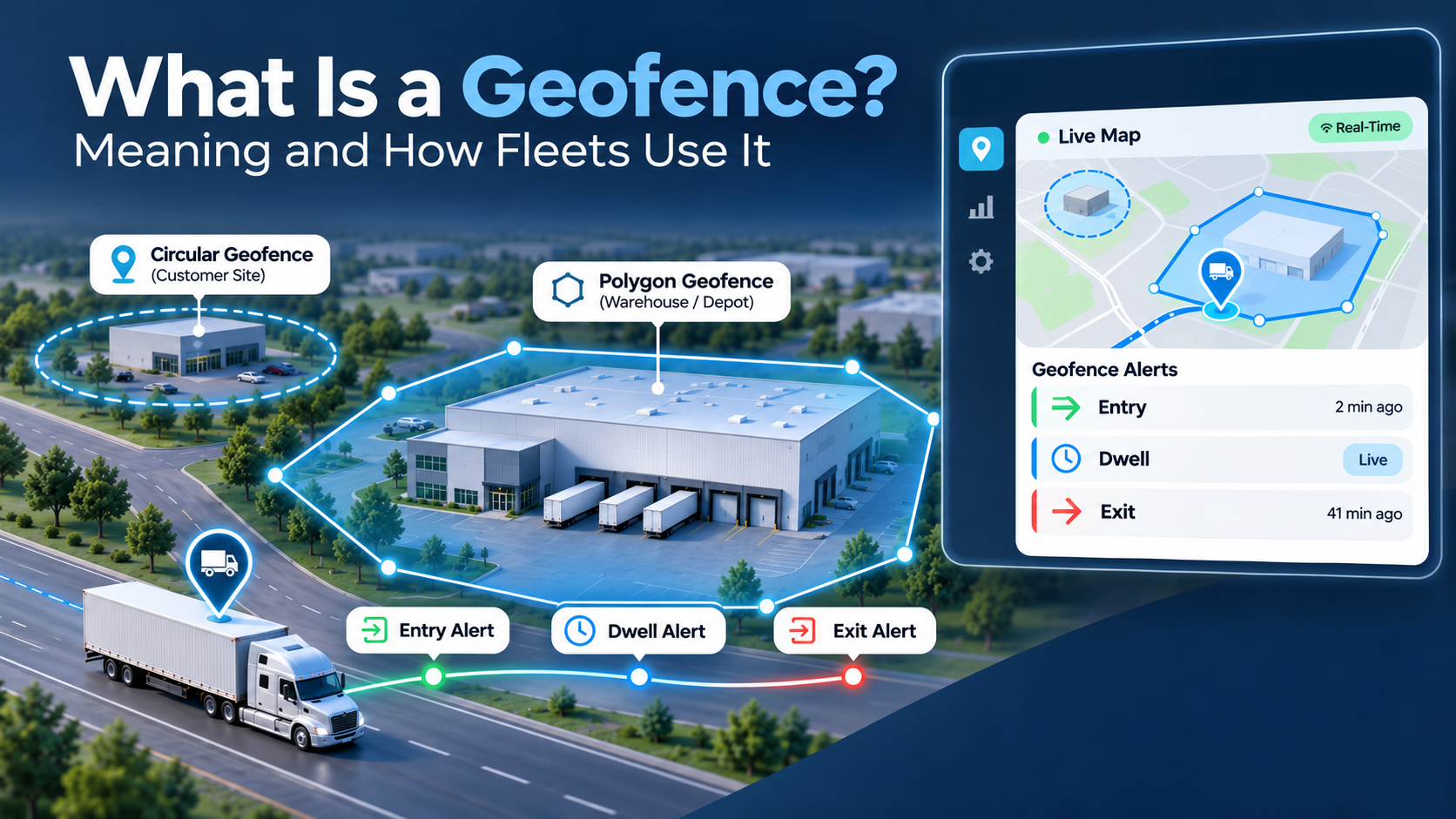
A geofence is a virtual perimeter drawn around a real-world location on a digital map. When a GPS-tracked vehicle, trailer or phone crosses it, software records the event and can trigger an alert or another automated action.
The geofence is the zone itself, and geofencing (also written geo fencing) is the practice of creating those zones and attaching rules to them.
How Does Geofencing Work in Fleet Tracking?
A GPS tracker in the vehicle reports its position at regular intervals. Fleet tracking software compares each position against the geofences you’ve drawn. When a vehicle crosses a boundary, or stays inside one past a set time, the software runs the rule you attached to that zone.
That’s why geofencing depends on reliable real-time GPS tracking, since fresher location data gets alerts to you sooner.
Entry, exit and dwell triggers
- Entry: a vehicle arrives at a zone, like a customer site.
- Exit: a vehicle leaves a zone, like your yard at 2 a.m.
- Dwell: a vehicle stays inside a zone longer than a set time, like three hours at a receiver’s dock.
Dwell triggers are the most useful for spotting wasted time, and Android’s geofencing guidance recommends them because they cut alerts from vehicles that only pass through briefly.
Circles, polygons and route corridors
A circle is the quickest zone: a center point and a radius. Some mapping platforms also support polygons drawn to match a property’s real outline, plus zones shaped around a route. Polygons suit yards and large sites, where a circle would either miss the back gate or spill onto the street next door.
How accurate is a geofence?
A geofence is only as precise as the location data behind it. According to GPS.gov, GPS-enabled phones are typically accurate to within about 4.9 meters (16 feet) under open sky, and accuracy drops near buildings, bridges and trees. Every zone still needs a small buffer so a truck parked at the edge of a lot doesn’t set off a string of in-and-out alerts.
7 Ways Fleets Use Geofences Every Day
- Catch after-hours vehicle use. Draw a zone around your yard and set it to alert only outside working hours. RouteMate Geofence supports time-based geofences for this, so a truck leaving at midnight gets attention right away.
- Log arrivals and departures automatically. Entry and exit events create a time-stamped record of every stop, which settles delivery disputes and improves ETAs.
- Measure dwell and detention time. The American Transportation Research Institute found that drivers were detained at 39.3% of stops in 2023, losing between 117 and 209 hours per driver each year. Dwell triggers at shippers and receivers give you the time stamps to bill detention and spot the slowest docks.
- Respond to theft faster. Verisk CargoNet estimated 2025 cargo theft losses at about $725 million, with the average theft valued at $273,990. An exit alert on a parked trailer, paired with real-time asset tracking, lets you act while the asset is still nearby.
- Reduce idling at sites. The EPA’s SmartWay program estimates that a typical combination truck burns about 0.8 gallons of diesel for every hour it idles. A dwell zone combined with engine status shows which sites leave trucks running.
- Flag restricted areas. Set entry alerts for low-clearance routes, residential streets or high-theft parking areas.
- Watch trailers and equipment. Get an alert when a trailer leaves a drop yard or a machine leaves a job site.
What Are the Benefits of Geofencing for Fleets?
Geofencing turns location data into automatic records and alerts. Fleets use it to reduce fuel waste, detect unauthorized use, bill for detention, give customers accurate ETAs and keep a time-stamped history of every stop, without anyone watching the map all day.
The FMCSA cites a 2018 DOT Inspector General finding that every 15 extra minutes of average dwell time raises the expected crash rate by 6.2%. Knowing where drivers lose time helps you plan safer appointments and routes.
How Do You Set Up a Geofence That Works?
Start with the locations that cost you the most, match each zone to the site’s outline, add dwell timers and schedules, send each alert to the person who can act on it, and review your geofence reports weekly.
- Pick your first 5 to 10 places, such as your yard, biggest customers and sites where trucks wait too long.
- Size each zone to the property, covering gates and parking plus a small buffer.
- Set dwell timers per site, like 30 minutes at a fuel stop or two hours at a dock.
- Schedule alerts, since a yard exit at 7 a.m. is normal while one at 1 a.m. deserves a call.
- Route alerts to the right person, with theft alerts going to the safety lead and detention alerts to billing.
- Review the data weekly. RouteMate GPS reports calculate time on site automatically, so patterns show up without spreadsheet work.
Geofencing Mistakes That Create Alert Fatigue
Geofencing fails quietly once people start ignoring the alerts. The usual causes:
- Zones drawn too tight, so GPS drift creates false entries and exits.
- Every alert sent to everyone, so nobody owns the response.
- No schedules, so normal daily movement buries the alerts that matter.
- Too many zones in week one, which makes it hard to tell which are useful.
- Reports nobody reads, so the data never turns into action.
Is Geofencing Legal? Privacy and Driver Trust
Using geofences on company-owned vehicles is common practice in the U.S., but notice rules differ from state to state. Tell drivers in writing what you track, when you track it and why, and check your state’s employee monitoring rules before you roll it out.
For example, New York has required employers since May 2022 to give new hires written notice of phone, email or internet monitoring and collect their acknowledgment, and Connecticut and Delaware have their own notice laws. These rules focus on electronic communications, but they point the same way: tell people first.
Trust also grows when drivers see the data working for them, since the same records that flag misuse prove on-time arrivals, document unpaid detention and help recover stolen trucks. This section is general information, not legal advice.
Put Geofences to Work in Your Fleet
A geofence lets your fleet tracking software watch the places that matter and tell you when something needs attention. Start with a handful of high-value locations, keep alerts meaningful with dwell timers and schedules, and review the reports so the data turns into decisions about fuel, detention and security.
Want to see how RouteMate Geofence fits your operation? Contact us and our team will help you set up your first zones.